The Elephant in Context
The first recorded use of the name "Elephant and Castle" was in 1765.10 It referred to the pub, once a blacksmiths, that over time lent its name to the entire area (see figs 1 & 2). It was an important staging post for travellers situated at the junction of several major roads heading out of the city into Sussex and Kent, which were greatly expanded during the late 18th and early 19th century with the construction of bridges at Westminster, Blackfriars, Vauxhall, Waterloo and Southwark.
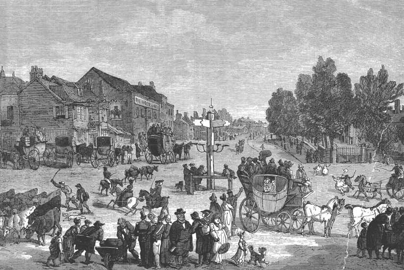
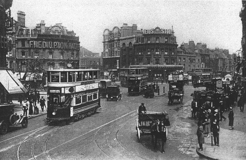
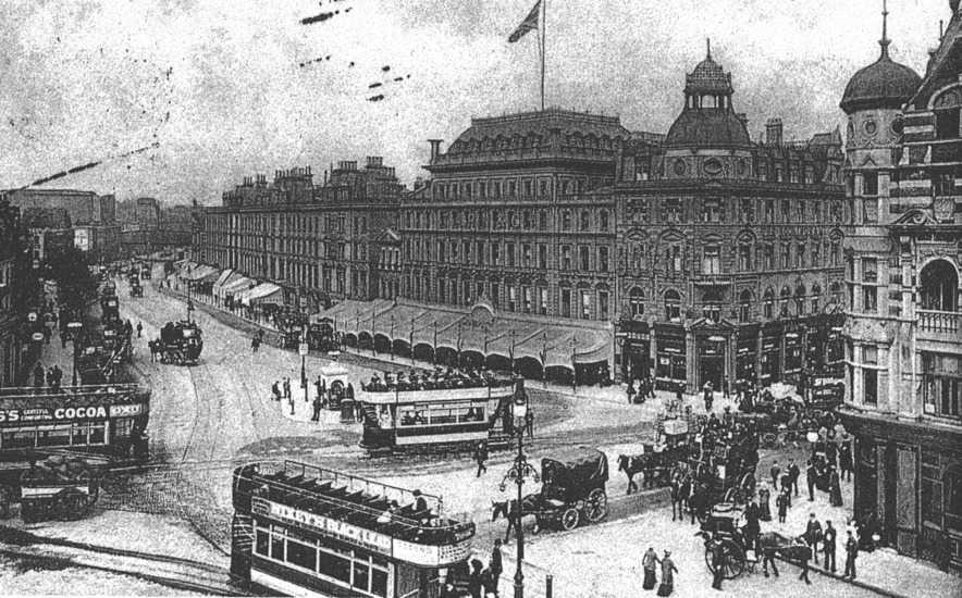
The 19th century was a period of great growth in the area (see figs 3 & 4). The population of the Parish of Walworth in 1801 was 14,847, by 1881 it was 107,850.11 The shift in the nature of the area was first realised with the arrival of the railway in 1862. It brought a large working class population into the area and with it more public houses, shops, theatres, music halls and also industry and large tenement blocks. During this time the area's notoriety for its confusion of traffic was added to by the introduction of horse drawn trams in 1870, electrified in 1903, and then the City & South London tube first in 1890 then again with the Baker Street & Waterloo line in 1906 (see fig map 5). At this time the population of the area had reached 122,172.12 In 1949 the old Elephant was described energetically in the Picture Post:
Its voice has the rasp of trams, trains and trucks. Its eyes have the blaze of street stalls, eel stands, pintable arcades and chestnut cans. Its anatomy is decked with sooty bricks, cast iron spires and the marble pillars of pubs. Its heart is that of its people-kind as a housewife, rough as a worker, busy as a tradesman and wide as a wide boy.13
Traffic and its communications had given the Elephant its prosperity and its identity, it seems somewhat ironic that later this would contribute to its undoing.
In the late nineteenth century, congestion came to be viewed more and more as an ill effect of the Victorian metropolis. There was increasing alarm that tortuous traffic flows were a threat to the transaction of business and that poor circulation in the city could have detrimental effects on social well being, as well as on economic success. One writer in an 1870s edition of Building News commented that, the chief centres in London, the City and Westminster [were] united by an indirect, obstructed, narrow lane - a mockery to be called a thoroughfare... if the streets of a city were compared to the veins of an animal, the Strand constitutes an aneurism in the most vital part of the body.
14 The physical analogy of London to the living body begs the question that if the City is considered its heart then what function has the Elephant and Castle? The late nineteenth century impulses towards improvement were the origins of re-planning the area and attempts to establish its role.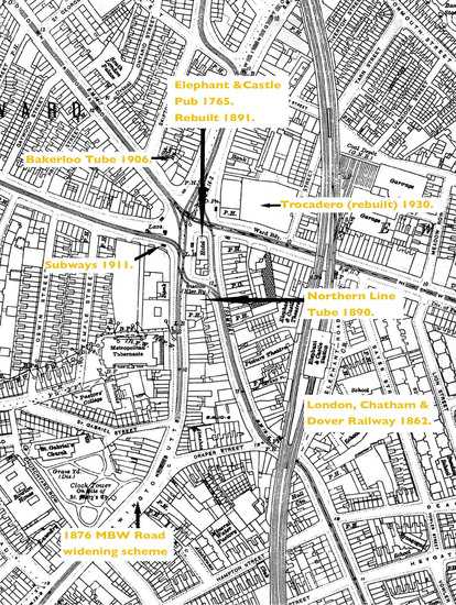 Figure 5
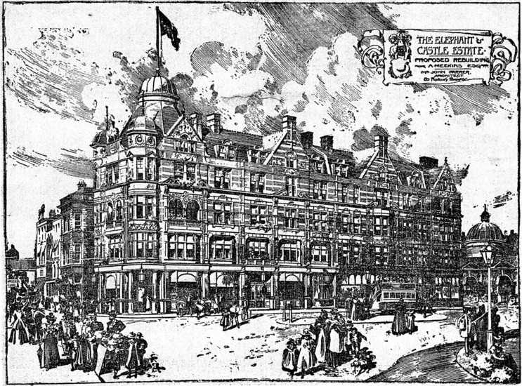 Figure 6
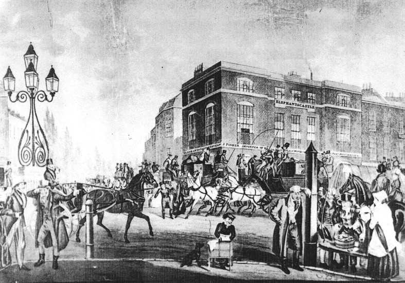
The first efforts of addressing the problems of traffic congestion in the area were made by the Metropolitan Board of Works. In 1876 the church of St Mary Newington was demolished for the widening of Newington Butts.15 The newly formed London County Council (LCC), charged with creating an efficient civic body, opened talks with the owners of the Elephant pub in 1892 with demolition in mind. The result was a narrower rebuilt pub of 1898 (see fig 6).16 The next attempt to address the problem of circulation was made in 1911 with Southwark Council constructing a small network of subways17, which for the first time separated pedestrians from traffic. They were noted for their disorientating effects (see map fig 5).
Following the First World War the changing nature of traffic and transport technology called for more radical solutions that placed the Elephant within its context of the larger metropolitan whole. Horse drawn traffic moved at approximately 4-5 mph.18 Haulage loads and distances were generally small, the bulk was carried by rail. Motorised vehicles provided greater flexibility, could carry more, faster and further. London's road network would have to respond to this and the rise of personal transport. In 1900 private car ownership stood at 2,000, by 1939 it would be 330,000.19
In 1926 the Ministry of Transport (MOT), conscious of the growth in motor traffic and therefore circulation, produced a large scale road scheme to create a southern ring road, which would see traffic diverted at some distance around the Elephant. Figure 7 shows an orbital route running from a new road bridge at Charing Cross along to Borough High Street, New Kent Road, down to Newington Butts and back up to Waterloo via Kennington. This scheme would certainly have robbed the Elephant of some of its importance. It would have been bypassed, severing it from its historic role for journeys south and entrances to the city.
A later scheme, possibly in conjunction with the last, was drawn up in 1929 also by the MOT. 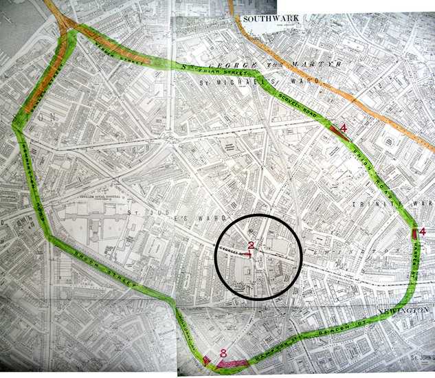 Figure 7
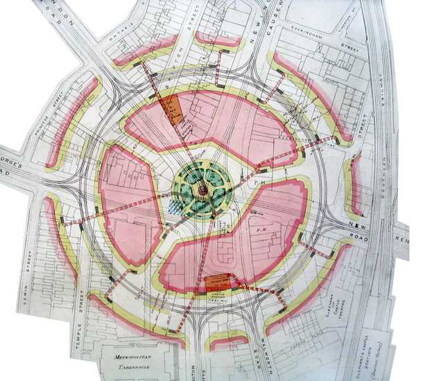 Figure 8This hugely ambitious plan would have turned the Elephant into a giant circus with a central circular commercial boulevard lined with trees and newly built tram and tube stations and a park at its centre (see fig 8). It would have been a slice of Burnham's 'City Beautiful'20 and would have certainly brought the Elephant great architectural prestige. A revised version of 1930, updated by the LCC, reveals something of the kind of treatment one could expect if it had been completed. The less radical layout appears to be a copy of the LCC's Aldwych & Kingsway scheme of 1905 (see figs 9 & 10). The last buildings of the Aldwych were being completed at this time and its belated success seems to have influenced the Council's thinking at the Elephant. Indeed, a Royal Commission on Traffic Conditions in 1930 heaped praise on the example of Kingsway commenting that, "This change epitomises the process we should like to see applied to London as a whole..."21 The plan was approved by Parliament, but construction was shelved owing to the limited availability of funds during the Great Depression.22
The MOT and LCC schemes belonged to a different era. Although they did provide much needed reorganisation of public modes of transportation, they merely aestheticised the problem of road congestion. They were decidedly Edwardian in their pomp and failed to provide a clear solution to congested traffic flows or realise growing changes in traffic habits. The advent of the motorcar age during the inter-war years called for more radical forms. Its dominance meant that in future roads would be made, "to accommodate traffic, not traffic constrained to suit the roads."23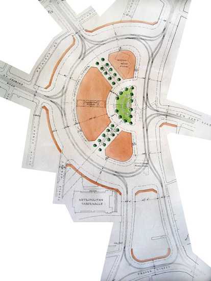 Figure 9
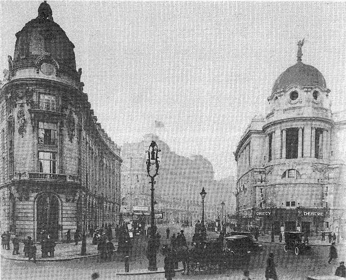 Figure 10
On the continent modernist architects proposed new visions of what type of city could be created around the automobile. Developing his ideas amongst the Parisian intelligentsia of the 1920s, Le Corbusier came to dominate discussion on a new urbanism. In terms of the living unit, Le Corbusier aimed for the architectural equivalent of the Model T Ford; a mass produced object that had been born of the machine age and perfectly fit for its purpose: a machine for living in.24 Speaking in 1922, Le Corbusier stressed the importance of modernising cities and the threat of traffic congestion and chaos.
The decay of old cities and present day working pressures are causing physical and mental illness... the layout of a city determines the physical and mental condition of its residents. Large cities govern the life of the nation. If large cities are stifled, the nation will founder!25
His remedy for metropolitan ills was large scale and comprehensive reconstruction. Le Corbusier called for nothing less than the complete reorganisation of the urban environment so that a healthier society may emerge through architectural order and diagrammatic harmony. Throughout the inter-war years he produced a series of highly innovative and influential proposals.The first came in 1922. In La Ville Contemporaine, a city for three million people is organised around a geometric arrangement of fast moving, efficient highways separating specialised districts of large scale residential and industrial units and commercial and administrative towers (see fig 11). The plan was based on four guiding principles, some of which were to have a profound effect upon post-war planning in the UK: relieve congestion at the centre, increase population densities, improve traffic flow and increase planted areas. Later urban planning schemes, Le Plan Voisin(1925) and La Ville Radieuse(1935), similarly used classified urban space and modular grids as their basis (see figs 12 & 13). 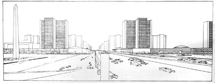 Figure 11
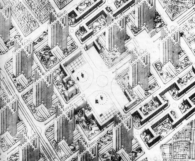 Figure 12
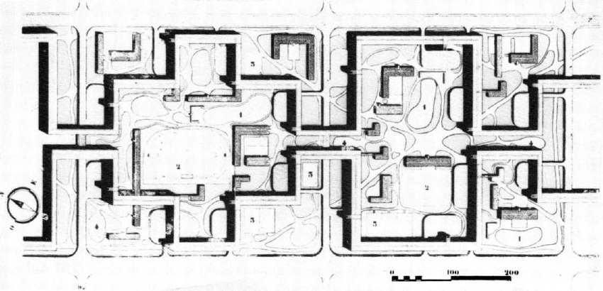 Figure 13They developed dynamic visual elements of elevated express highways and service roads separated from a landscaped pedestrian ground level. In La Ville Radieuse residential blocks would be raised on stilts or pilotis enabling uninterrupted pedestrian realms of green spaces traversed by highways to create a dynamic townscape that banished traditional street development. Le Corbusier was against a continuous urban sprawl. "A modern city," he said, "should have no suburbs. Modern techniques allow us to recover in height what we lose in breadth."26 However, in the United States of America, the car was already promoting the opposite.
In America, the world's first car owning democracy, the pressures of mass motorisation were being felt in the 1920s in a way the rest of the world would not know until the 1950s and 1960s.27 The American response to the problems of congestion in the city was to abandon the city altogether. During the 1920s rising levels of car ownership led to a massive growth of the suburbs (see fig 14). Ordinary workers could live further from their place of work, while property developers were no longer tied to public transport networks for access. Los Angeles, more than any other city, provided a stark indicator as to the nature of the future car-dependancy. In 1920 there was one car for every 3.6 citizens.28 A chronically congested downtown persuaded a car owning populace to seek their services elsewhere. The result was a swift rejection of the centre in favour of multiple regional centres tied to a decentralised network of roads. This model would prove irresistible for London's late twentieth century expansion.
The lesson of inter-war Los Angeles provided impetus for Frank Lloyd Wright's automotive utopia, which took decentralisation to its climax. Broadacre City, part of Wright's 1932 publication, 'The Disappearing City'29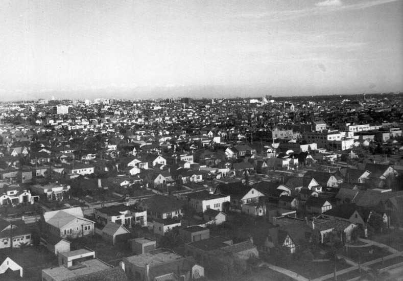 Figure 14
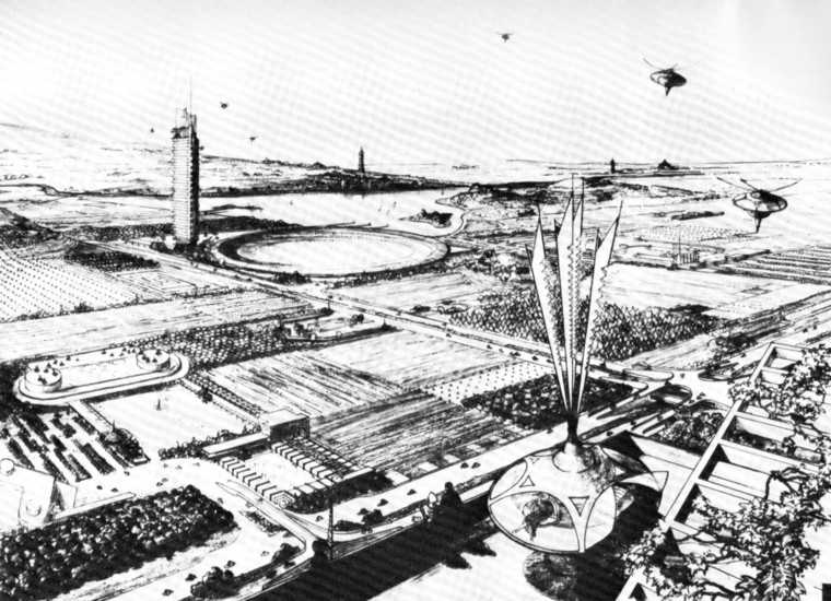 Figure 15 provided a contrast to that envisaged by Le Corbusier. It championed the new urban scale made possible by the motor car by blurring urban and rural definitions. The car provided a "new mastery of time and space,"30 and made possible a vast man made environment, which could be distributed across the countryside (see fig 15). In contrast to European models, Wright rejected both the re-imagined urban centre and the traditional suburb and promoted dispersal through the establishment of homesteads linked by highways: "The expensive concentrations of people was merely wasteful when modern means of communication could overcome distance."31
In London, continental visions of the future seemed far fetched. Devotees of the modern age and auto-enthusiasts had to be content with streamlined flats and garage combinations, that intimated notions of speed together with a few isolated road bypass schemes.32 Traditional suburban expansion continued with cars accelerating its desirability. The result, as seen on a larger scale in North America, was tracts of "repellent,"semi-detached sprawl described by J.B. Priestley in 'English Journey', peppered by "filling stations and factories that look like exhibition buildings, of giant cinemas and dance halls and cafes, bungalows with tiny garages."33 The momentum against unregulated development and towards planning for cars gathered pace in 1936 with the Trunk Roads Act34 and in 1937 with the Barlow Commission on the State of Traffic in Towns. This was followed by The Highway Development Survey by Sir Charles Bressey and Sir Edwin Luytens. Both made several recommendations for central planning, reorganisation and reconstruction, but it was the devastation of the Second World War, which ushered in an architectural climate in London that would encourage a new relationship of roads to the built environment.
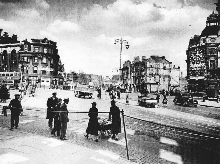
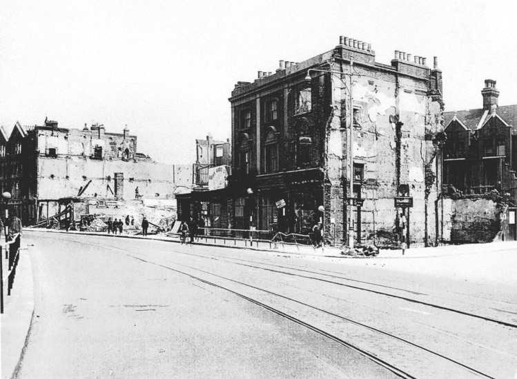
On May the 10th and 11th 1941 the Elephant and Castle suffered heavy attacks in the Blitz.35 Around one third of the built environment was destroyed36 (see figs 16 & 17). It was the golden opportunity planners had been waiting for. Rebuilding London had long been in discussion, with many parties submitting plans for reconstruction. Among them was London Replanned(1942), a high profile Royal Academy publication calling for a grandiose new capital. It featured an admirable scheme for a large-scale circular park for the Elephant and Castle area connected by yet more boulevards and formalised spaces (see fig 18).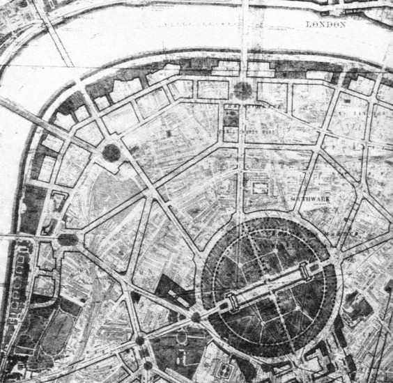 Figure 18
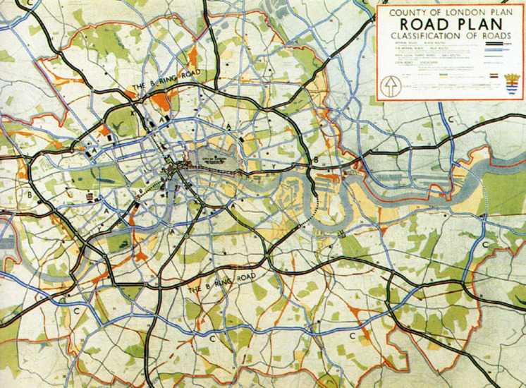
However, it was Abercrombie's large scale County of London Plan of 1943 that provided the blueprint for future development of the city and in particular the Elephant and Castle. Among his system of arterial and radial roads, Abercrombie highlighted the Elephant as a 'gateway' on a par with Hyde Park Corner:
There are many focal points in Central London, which require remodelling on plan and will offer opportunities for fine architectural treatment... the necessities of traffic weaving will dominate their design37
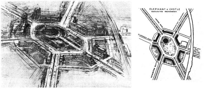
The plan called for a huge traffic circus surrounded by vaguely Stalinist structures that formed axial arrangements and gateway features for travel northwards towards the West End (see fig 19). Roads and cars dominate the scene. According to one reaction, the Elephant would be "better known than it has ever been," central to a system of "majestic"38 urban highways heading south (see fig 20). The sketch and plan, showing the suggested treatment of the area, became the essential basis of redevelopment during the post-war years.
Footnotes for chapter.
- ↑ Boast, M, The Story of Walworth, 1993. p.25.
- ↑ Boast, 1993. p.31.
- ↑ Boast, 1993. p.31. Population figure based on 1901 reports.
- ↑ Picture Post 1949. Taken from Collins, Michael, 'The Elephant's Graveyard,' The Observer Magazine, December 23rd, 2001.
- ↑ Nead, Lynda, Victorian Babylon, 2000. p.163.
- ↑ Richardson, Tim, Elephant & Castle Comprehensive Development Area: Analysis of the Redevelopment of the Elephant & Castle 1955-1965, 1979. p.420.3. The congregation of St Mary had built a larger new building further down the street.
- ↑ Ibid. pp.420-3.
- ↑ Price-Myers, Sam, London South of the River, 1949. p.21.
- ↑ MacEwen in The Architects Journal, 1959. p.256.
- ↑ Wilcox, D & Richards, D, London: The Heartless City, 1977. p.54.
- ↑ Daniel Burnham produced a grandiose plan for Chicago in 1909 based on a geometric arrangement of Haussmann style boulevards. It was hugely influential for the largely ceremonial reconstruction of North American cities in the 1920's. See Hall, P, Cities of Tomorrow (Third Edition), 2002. p.189.
- ↑ Ashworth, William, The Genesis of Modern British Town Planning (Fourth Edition 1972). p.115.
- ↑ Williams, H, South London, 1949. p.114.
- ↑ Webb, S & Webb, B, English Local Government From Revolution to the Municipal Corporations Act. Volume Five: The Story of the Kings Highway (New Edition), 1967. p.147.
- ↑ Benton, Tim in Arts Council of Great Britain, Le Corbusier: Architect of the Century, 1987. p.208.
- ↑ Guiton, Jacques & Guiton, Margaret, The Ideas of Le Corbusier on Architecture and Urban Planning, 1981. p.94.
- ↑ Ibid. p.107.
- ↑ Hall, Peter, Cities of Tomorrow (Third Edition), 2002. p.296.
- ↑ Longstreth, Richard, City Center to Regional Mall, 1997. p.13.
- ↑ Fishman, Robert, Urban Utopias in the Twentieth Century: Ebenezer Howard, Frank Lloyd Wright and Le Corbusier, 1977. p.123.
- ↑ Ibid. p.93.
- ↑ Ibid. p.123.
- ↑ Early progress: Kingston A3 bypass, the North Circular and Watford relief road all built during inter-war years.
- ↑ Priestley, J.B, English Journey,1934. Quoted in Wollen, P & Kerr, J Autopia: Cars and Culture, 2002. p.234.
- ↑ Hamer, Mark, Wheels Within Wheels: A Study of the Road Lobby, 1987. p.40. The 1936 Act put trunk roads in central government hands. The Times criticised it as 'Nationalisation'.
- ↑ Richardson, Tim, Elephant & Castle Comprehensive Development Area: Analysis of the Redevelopment of the Elephant & Castle 1955-1965, 1979. 420.3.
- ↑ From the Municipal Journal & Local Government Administrator, October 25th, 1946. Area cleared by wartime bombs put at 33%.
- ↑ J.H. Forshaw & P.Abercrombie, County of London Plan, 1943. p.138.
- ↑ From The Star, October 10th, 1943. "All Change at the Elephant."